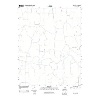
2010 Map of Mocane SE
USGS Topo · Published 2010About this map
The Beaver River meanders across this High Plains landscape in Beaver County, serving as the central hydrological feature of the region. The surrounding terrain is defined by a sparse network of section-line roads and named hollows, including Hollow N1510 and Hollow E0098, which navigate the subtle drainage patterns of the Oklahoma Panhandle. This area, largely agricultural and rural, is drained by several seasonal tributaries such as Spring Creek, Camp Creek, and Duck Pond Creek. The map illustrates the characteristic grid-based infrastructure of the American West, where property and passage are strictly defined by the township and range system, even as the river's winding path provides a natural contrast to the geometric precision of the Hollow N1540 road network.
Find a feature on this map
30 named features on this map. Tap any name to fly to it.
Don’t see what you’re looking for? This feature index may not catch every label — zoom into the map to look around manually.
Map Details
Editions of this 2010 Mocane SE Map
This is the sole edition of this map. No revisions or reprints were ever made.
Other maps of this area

1954 · Perryton
USGS Topo · 1:250,000

1958 · Perryton
USGS Topo · 1:250,000

1970 · Knowles
USGS Topo · 1:24,000

1970 · Gate NW
USGS Topo · 1:24,000

1970 · Mocane NW
USGS Topo · 1:24,000

1970 · Mocane SE
USGS Topo · 1:24,000
1970 · Mocane
USGS Topo · 1:24,000

1971 · Clear Lake NW
USGS Topo · 1:24,000

1971 · Clear Lake
USGS Topo · 1:24,000

1971 · Logan NW
USGS Topo · 1:24,000