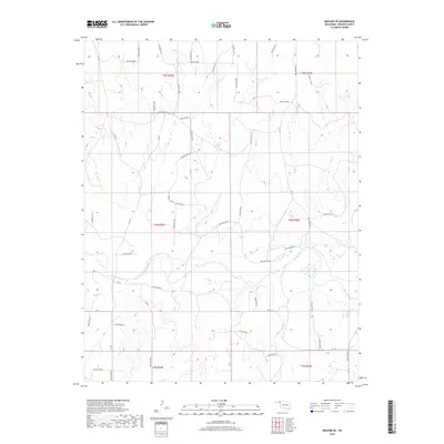
2018 Map of Mocane SE
USGS Topo · Published 2018About this map
The Beaver River meanders across this High Plains landscape in Beaver County, defining the drainage patterns of the central Oklahoma Panhandle. This 2018 survey documents a region characterized by its systematic section-line road network, including routes like Ew-15 and NS-148, which serve as the primary conduits through the rural terrain. The hydrology is dominated by seasonal and perennial drainages such as Spring Cr, Camp Cr, and Duck Pond Cr, which feed into the primary river valley. Numerous named topographic depressions, such as Hollow N1480 and Hollow D0130, illustrate the subtle but complex erosion patterns of the region. The map provides a contemporary record of land divisions and access, noting areas with No Acc, which is essential for understanding modern land use and historical property boundaries in this part of the state.
Find a feature on this map
52 named features on this map. Tap any name to fly to it.
Don’t see what you’re looking for? This feature index may not catch every label — zoom into the map to look around manually.
Map Details
Editions of this 2018 Mocane SE Map
This is the sole edition of this map. No revisions or reprints were ever made.
Other maps of this area

1954 · Perryton
USGS Topo · 1:250,000

1958 · Perryton
USGS Topo · 1:250,000

1970 · Knowles
USGS Topo · 1:24,000

1970 · Gate NW
USGS Topo · 1:24,000

1970 · Mocane NW
USGS Topo · 1:24,000

1970 · Mocane SE
USGS Topo · 1:24,000
1970 · Mocane
USGS Topo · 1:24,000

1971 · Clear Lake NW
USGS Topo · 1:24,000

1971 · Clear Lake
USGS Topo · 1:24,000

1971 · Logan NW
USGS Topo · 1:24,000