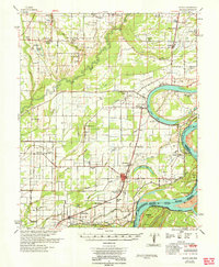
1964 Map of Modoc
USGS Topo · Published 1964About this map
Old Town Lake and the meandering curves of the Mississippi River define the Delta landscape of Phillips County in the early 1960s. This survey, conducted under the direction of the Mississippi River Commission, reveals a rural economy deeply tied to the land and the river's whims, as evidenced by the Modoc Crevasse and the numerous bayous like Gowan Bayou and Beaver Bayou that drain the floodplain. The area is dense with small community landmarks, including the Rosenwald Sch, reflecting the local education history of the era.
Find a feature on this map
70 named features on this map. Tap any name to fly to it.
Don’t see what you’re looking for? This feature index may not catch every label — zoom into the map to look around manually.
Map Details
Editions of this 1964 Modoc Map
This is the sole edition of this map. No revisions or reprints were ever made.
Other maps of this area

1930 · Mellwood
USGS Topo · 1:62,500

1935 · Clarksdale
USGS Topo · 1:62,500

1939 · Farrell
USGS Topo · 1:62,500

1939 · Modoc
USGS Topo · 1:62,500

1939 · Indian Bay
USGS Topo · 1:62,500

1939 · Henrico
USGS Topo · 1:62,500

1939 · Clarksdale
USGS Topo · 1:62,500

1939 · Latour
USGS Topo · 1:62,500

1939 · Mellwood
USGS Topo · 1:62,500

1940 · Marvell
USGS Topo · 1:62,500