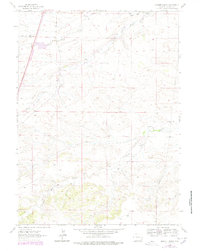
1962 Map of Moffett Ranch
USGS Topo · Published 1978About this map
Moffett Ranch and Snow Ranch anchor this high-plains landscape in Laramie County, illustrating the remote ranching operations active in the early 1960s. The drainage systems of North Bear Creek, South Fork Bear Creek, and Little Bear Creek dictate the local topography, providing essential water sources marked by scattered Springs. Significant infrastructure developments are visible in the western portion of the sheet, where a major route is noted as Under Construction alongside the established Chalk Hill Road. This era of transition is further evidenced by a long Pipeline cutting across the terrain and a Pumping Station situated near the creek beds, reflecting the modernization of resource management and transportation networks in this Wyoming ranchland during the mid-20th century.
Find a feature on this map
11 named features on this map. Tap any name to fly to it.
Don’t see what you’re looking for? This feature index may not catch every label — zoom into the map to look around manually.
Map Details
Editions of this 1962 Moffett Ranch Map
3 editions found
Other maps of this area

1911 · Cheyenne
USGS Topo · 1:125,000

1914 · Cheyenne
USGS Topo · 1:125,000

1954 · Cheyenne
USGS Topo · 1:250,000

1958 · Cheyenne
USGS Topo · 1:250,000

1962 · Moffett Ranch
USGS Topo · 1:24,000

1962 · Lewis Ranch
USGS Topo · 1:24,000

1962 · Bristol Ridge
USGS Topo · 1:24,000
1962 · Nimmo Ranch
USGS Topo · 1:24,000

1962 · Bristol Ridge NE
USGS Topo · 1:24,000
1962 · Whitcomb Hill
USGS Topo · 1:24,000