
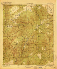
1985 Map of Mogollon Mountains
USGS Topo · Published 1985About this map
Gila Cliff Dwellings National Monument stands as a significant cultural focal point within the high country of the Mogollon Mountains. This 1985 survey captures the complex drainage systems of the Gila River and the San Francisco River just as the region was being managed under expansive conservation designations like the Gila Wilderness and the Aldo Leopold Wilderness. Small settlements such as Mogollon, Alma, and Glenwood cling to the rugged valley corridors, while the presence of the Confidence Mine and Gold Dust Mine points to the area's history of mineral extraction. The map details a landscape of extreme vertical relief, from the heights of Granite Peak and Sacaton Mountain down to the remote Landing Strip and school locations that serve these isolated mountain communities.
Find a feature on this map
41 named features on this map. Tap any name to fly to it.
Don’t see what you’re looking for? This feature index may not catch every label — zoom into the map to look around manually.
Map Details
Editions of this 1985 Mogollon Mountains Map
This is the sole edition of this map. No revisions or reprints were ever made.
Other maps of this area
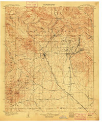
1909 · Silver City
USGS Topo · 1:125,000

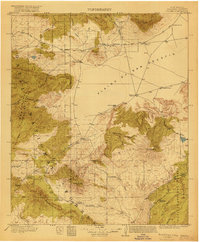
1910 · Mogollon
USGS Topo · 1:125,000

1911 · Alum Mountain
USGS Topo · 1:125,000

1912 · Mogollon
USGS Topo · 1:125,000

1913 · Alum Mountain
USGS Topo · 1:125,000

1913 · Morenci
USGS Topo · 1:125,000

1915 · Morenci
USGS Topo · 1:125,000

1915 · Reserve
USGS Topo · 1:125,000
1918 · Pelona
USGS Topo · 1:125,000
1918 · Reserve
USGS Topo · 1:125,000