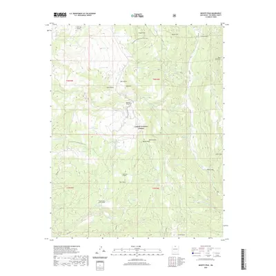
2020 Map of Mogote Peak
USGS Topo · Published 2020About this map
Carson National Forest encompasses this high-altitude landscape in Rio Arriba County, where the Continental Divide National Scenic Trail winds through the Tusas Mountains. This 2020 survey details a complex network of canyons and high ridges, including Mogote Peak and the prominent Mogote Ridge. The region is defined by its seasonal water sources, marked by numerous named tanks and springs such as Llamo Tank, Amarilla Tank, and the Acequia de troughs Spring. High-country basins hold several lakes, most notably Laguna Pinabete Mocho and Puertecito de las Ranas. The terrain transitions from deep incisions like Madera Cañon and Cañon Largo to the elevated expanse of Banco Lona. This map serves as a precise record of the traditional land divisions and hydrology of Northern New Mexico's timberline country.
Find a feature on this map
56 named features on this map. Tap any name to fly to it.
Don’t see what you’re looking for? This feature index may not catch every label — zoom into the map to look around manually.
Map Details
Editions of this 2020 Mogote Peak Map
This is the sole edition of this map. No revisions or reprints were ever made.
Other maps of this area

1918 · Abiquiu
USGS Topo · 1:125,000

1918 · Tusas
USGS Topo · 1:125,000

1953 · Valle Grande Peak
USGS Topo · 1:24,000

1953 · Magote Peak
USGS Topo · 1:24,000

1953 · Canjilon
USGS Topo · 1:24,000

1953 · El Rito
USGS Topo · 1:24,000

1953 · Canjilon SE
USGS Topo · 1:24,000

1953 · Ghost Ranch
USGS Topo · 1:24,000

1954 · Aztec
USGS Topo · 1:250,000

1955 · Cebolla
USGS Topo · 1:62,500