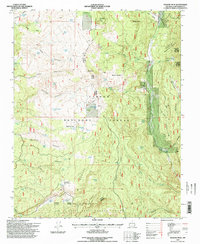
1995 Map of Mogote Peak
USGS Topo · Published 1998About this map
Mogote Peak and the high Tusas Mountains dominate this high-altitude landscape in Carson National Forest during the mid-1990s. The region is defined by complex topography, with Mogote Ridge separating a series of deep canyons and volcanic-formed benches like Banco Lona and Banco Aragon. This area reflects a long history of land management and natural resource use, evidenced by the Vallecitos Federal Sustained Yield Unit and the presence of numerous livestock-related features including Rancherilla Corral and several Gravel Pits.
Find a feature on this map
64 named features on this map. Tap any name to fly to it.
Don’t see what you’re looking for? This feature index may not catch every label — zoom into the map to look around manually.
Map Details
Editions of this 1995 Mogote Peak Map
This is the sole edition of this map. No revisions or reprints were ever made.
Other maps of this area

1918 · Abiquiu
USGS Topo · 1:125,000

1918 · Tusas
USGS Topo · 1:125,000

1953 · Valle Grande Peak
USGS Topo · 1:24,000

1953 · Magote Peak
USGS Topo · 1:24,000

1953 · Canjilon
USGS Topo · 1:24,000

1953 · El Rito
USGS Topo · 1:24,000

1953 · Canjilon SE
USGS Topo · 1:24,000

1953 · Ghost Ranch
USGS Topo · 1:24,000

1954 · Aztec
USGS Topo · 1:250,000

1955 · Cebolla
USGS Topo · 1:62,500