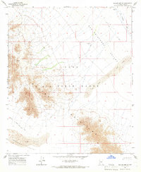
1965 Map of Mohawk Mts SE
USGS Topo · Published 1966About this map
Luke Air Force Range dominates this mid-1960s survey of the Sonoran Desert, where military boundaries intersect with the natural landforms of the Mohawk Mountains. The landscape is defined by its arid extremes, from the broad San Cristobal Valley to the shifting Sand Dunes that accumulate along its eastern edge. Evidence of human attempts to secure water in this environment is visible at Spains Well (Dry) and White Well (Dry), both noted as dry by the time of this 1965 field check. A network of Jeep Trails and the Pagapo Well (Jeep) Road provide the only access through the rugged terrain, which includes the distinctive Natural Arch formation. The map also traces the winding course of the San Cristobal Wash and the southern reaches of the Mohawk Valley, illustrating the intersection of defense land use and desert geography.
Find a feature on this map
12 named features on this map. Tap any name to fly to it.
Don’t see what you’re looking for? This feature index may not catch every label — zoom into the map to look around manually.
Map Details
Editions of this 1965 Mohawk Mts SE Map
2 editions found
Other maps of this area

1927 · Aguila Mountains
USGS Topo · 1:48,000

1927 · Kim
USGS Topo · 1:62,500

1930 · Aguila Mountains
USGS Topo · 1:62,500

1931 · Kim
USGS Topo · 1:62,500

1953 · Ajo
USGS Topo · 1:250,000

1957 · Ajo
USGS Topo · 1:250,000

1958 · Ajo
USGS Topo · 1:250,000

1962 · Ajo
USGS Topo · 1:250,000

1963 · Ajo
USGS Topo · 1:250,000
1965 · Mohawk Mts NW
USGS Topo · 1:24,000