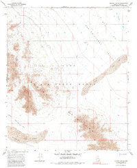
1965 Map of Mohawk Mts SE
USGS Topo · Published 1985About this map
The arid expanse of the San Cristobal Valley dominates this 1960s survey, defined by the stark isolation of the Mohawk Mountains and the extensive Luke Air Force Range. This desert landscape is characterized by limited water sources and shifting geology, featuring a prominent band of Sand Dunes cutting through the valley floor and the seasonal San Cristobal Wash to the northeast. Human presence is marked by ephemeral infrastructure like the Pagapo Well (Jeep) Road and remote outposts such as Spains Well (Dry) and White Well (Dry), both noted as dry during the survey. Geological landmarks like the Natural Arch punctuate the high ridges of the Mohawk range, while the southern reaches descend into the Mohawk Valley, showing the transition into the Mohawk Sand Dunes.
Find a feature on this map
13 named features on this map. Tap any name to fly to it.
Don’t see what you’re looking for? This feature index may not catch every label — zoom into the map to look around manually.
Map Details
Editions of this 1965 Mohawk Mts SE Map
2 editions found
Other maps of this area

1927 · Aguila Mountains
USGS Topo · 1:48,000

1927 · Kim
USGS Topo · 1:62,500

1930 · Aguila Mountains
USGS Topo · 1:62,500

1931 · Kim
USGS Topo · 1:62,500

1953 · Ajo
USGS Topo · 1:250,000

1957 · Ajo
USGS Topo · 1:250,000

1958 · Ajo
USGS Topo · 1:250,000

1962 · Ajo
USGS Topo · 1:250,000

1963 · Ajo
USGS Topo · 1:250,000
1965 · Mohawk Mts NW
USGS Topo · 1:24,000