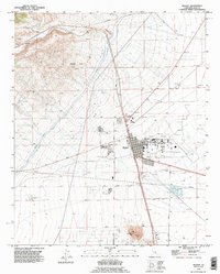
1992 Map of Mojave
USGS Topo · Published 1995About this map
Horned Toad Hills rise above the high desert floor where the Los Angeles Aqueduct and Second Los Angeles Aqueduct cut south toward the coast. The settlement of Mojave serves as a major logistical hub, defined by the massive footprint of the Mojave Airport and the junction of the Southern Pacific railroad lines. To the south, industrial extraction is evident at Standard Hill and an Open Pit Mine, while the landscape is dotted with several Gravel Pits and Prospects. Despite the arid terrain marked by Cache Creek, the map shows developed social infrastructure including Mojave West Park, an Athletic Field, and a Golf Course. Smaller named locales like Chaffee and Fleta emphasize the area's role in rail and transport history during the late twentieth century.
Find a feature on this map
42 named features on this map. Tap any name to fly to it.
Don’t see what you’re looking for? This feature index may not catch every label — zoom into the map to look around manually.
Map Details
Editions of this 1992 Mojave Map
This is the sole edition of this map. No revisions or reprints were ever made.
Other maps of this area

1915 · Elizabeth Lake
USGS Topo · 1:125,000

1915 · Mojave
USGS Topo · 1:125,000

1917 · Elizabeth Lake
USGS Topo · 1:125,000

1943 · Rosamond
USGS Topo · 1:62,500

1943 · Tehachapi
USGS Topo · 1:62,500

1943 · Mojave
USGS Topo · 1:62,500

1943 · Willow Springs
USGS Topo · 1:62,500

1947 · Plano
USGS Topo · 1:24,000

1947 · Mojave
USGS Topo · 1:24,000
1947 · Bissell
USGS Topo · 1:24,000