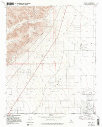
1973 Map of Mojave NE
USGS Topo · Published 1994About this map
California City sits at the heart of this high desert landscape, showing the ambitious mid-century planning of a master-planned community in the Antelope Valley and Fremont Valley. The grid of proposed streets, such as Lindbergh Blvd, Cheyenne Blvd, and Poppy Blvd, extends far into the desert, illustrating a moment of significant speculative growth. To the west, the Barren Ridge rises sharply, bisected by the Los Angeles Aqueduct, a critical piece of infrastructure that winds through the foothills near Tree Canyon. The map reveals the contrast between the rigid geometric layout of the developing city and the topographical complexity of the nearby ridges and canyons, where siphons and springs denote the essential movement of water through this arid environment.
Find a feature on this map
23 named features on this map. Tap any name to fly to it.
Don’t see what you’re looking for? This feature index may not catch every label — zoom into the map to look around manually.
Map Details
Editions of this 1973 Mojave NE Map
4 editions found
Other maps of this area

1915 · Searles Lake
USGS Topo · 1:250,000

1915 · Mojave
USGS Topo · 1:125,000

1943 · Cross Mountain
USGS Topo · 1:62,500

1943 · Saltdale
USGS Topo · 1:62,500

1943 · Castle Butte
USGS Topo · 1:62,500

1943 · Mojave
USGS Topo · 1:62,500

1947 · Castle Butte
USGS Topo · 1:50,000

1947 · Plano
USGS Topo · 1:24,000

1947 · Mojave
USGS Topo · 1:24,000

1947 · Desert Butte
USGS Topo · 1:24,000