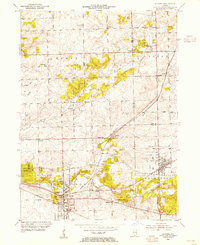
1953 Map of Mokena
USGS Topo · Published 1955About this map
Mokena and New Lenox anchor this mid-century survey of the Illinois prairie south of Chicago, showing a landscape defined by traditional agriculture and early suburban expansion. The era's transportation network is prominently displayed, featuring the Chicago Rock Island and Pacific and Wabash railroads alongside historic thoroughfares like the Lincoln Highway. The map captures a high density of rural institutions, including one-room schools such as Wells Corner Sch, Lynk Sch, and Francis Sch, many of which were still active or recently transitioned during this period.
Find a feature on this map
53 named features on this map. Tap any name to fly to it.
Don’t see what you’re looking for? This feature index may not catch every label — zoom into the map to look around manually.
Map Details
Editions of this 1953 Mokena Map
This is the sole edition of this map. No revisions or reprints were ever made.
Other maps of this area

1890 · Des Plaines
USGS Topo · 1:62,500

1892 · Joliet
USGS Topo · 1:62,500

1892 · Wilmington
USGS Topo · 1:62,500

1894 · Des Plaines
USGS Topo · 1:62,500

1900 · Des Plaines
USGS Topo · 1:62,500

1901 · Des Plaines
USGS Topo · 1:62,500

1918 · Wilmington
USGS Topo · 1:62,500

1923 · Joliet
USGS Topo · 1:62,500

1928 · Palos Park
USGS Topo · 1:24,000

1928 · Sag Bridge
USGS Topo · 1:24,000