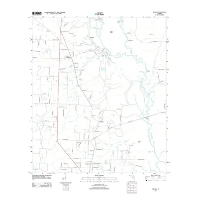
2012 Map of Molino
USGS Topo · Published 2012About this map
The Escambia River defines the eastern landscape of this Florida panhandle quadrangle, carving a complex network of bayous and islands like Morgan Island and Parker Island. Along the high ground west of the river, the settlements of Brickton, Molino Crossroads, and Quintette follow the north-south transit corridor of Hwy 97. This area shows the distinct transition from the river's wetland ecology, marked by numerous lakes such as Dead Lake and Beaverdam Lake, to the more developed agricultural and residential tracts near Cottage Hill. Local family and community history is preserved at the Vaughn Cem and Barrineau Cem, while landmarks like the Molino Fire Tower and river access points at Webb Landing and Proctors Landing illustrate the region's enduring connection to the timber-rich river basin.
Find a feature on this map
130 named features on this map. Tap any name to fly to it.
Don’t see what you’re looking for? This feature index may not catch every label — zoom into the map to look around manually.
Map Details
Editions of this 2012 Molino Map
This is the sole edition of this map. No revisions or reprints were ever made.
Other maps of this area

1920 · Milton
USGS Topo · 1:62,500

1921 · Muscogee
USGS Topo · 1:62,500

1941 · Muscogee
USGS Topo · 1:62,500

1941 · Milton
USGS Topo · 1:62,500

1941 · Century
USGS Topo · 1:62,500

1943 · Muscogee
USGS Topo · 1:62,500

1943 · Century
USGS Topo · 1:62,500

1943 · Milton
USGS Topo · 1:62,500

1943 · Jay
USGS Topo · 1:62,500
1944 · Floridatown
USGS Topo · 1:25,000