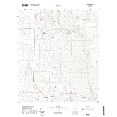
2021 Map of Molino
USGS Topo · Published 2021About this map
The Escambia River corridor defines the eastern edge of this landscape, where the main channel and its sprawling backwaters create a complex network of islands and oxbow lakes. Numerous landmarks such as Morgan Island, Parker Island, and the curiosity of the Mound reflect a terrain shaped by the river's shifting course. Further inland, the settlements of Molino, Quintette, and Cottage Hill serve as local hubs, connected by a web of rural roads including Brickton Rd and Hwy 196. This map provides significant detail for local historians and genealogists, pinpointing family-named sites like Vaughn Cem and Barrineau Cem, along with Crabtree Church. The names of the waterways, such as Sawdust Lake and Buffalo Mill Cr, suggest a history tied to the early timber industry that once flourished along these banks.
Find a feature on this map
137 named features on this map. Tap any name to fly to it.
Don’t see what you’re looking for? This feature index may not catch every label — zoom into the map to look around manually.
Map Details
Editions of this 2021 Molino Map
This is the sole edition of this map. No revisions or reprints were ever made.
Other maps of this area

1920 · Milton
USGS Topo · 1:62,500

1921 · Muscogee
USGS Topo · 1:62,500

1941 · Muscogee
USGS Topo · 1:62,500

1941 · Milton
USGS Topo · 1:62,500

1941 · Century
USGS Topo · 1:62,500

1943 · Muscogee
USGS Topo · 1:62,500

1943 · Century
USGS Topo · 1:62,500

1943 · Milton
USGS Topo · 1:62,500

1943 · Jay
USGS Topo · 1:62,500
1944 · Floridatown
USGS Topo · 1:25,000