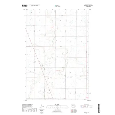
2017 Map of Monango
USGS Topo · Published 2017About this map
Monango stands as the central hub of this prairie landscape in Dickey County, situated along a north-south transportation corridor that intersects with local thoroughfares like Main Ave and 2nd Ave. The town’s history is anchored by the Monango City Cem located just to the northwest. The surrounding terrain is defined by the winding course of the Maple River, which meanders across the northern sections before being joined by the S Fork Maple River in the east. This 2017 survey reveals a classic Great Plains township grid, where section lines are marked by rural roads such as 85th St SE and Dickey Cty 3. The abundance of small wetlands and depressions scattered across the map illustrates the glacial prairie pothole topography that dictates the drainage patterns of this agricultural region.
Find a feature on this map
18 named features on this map. Tap any name to fly to it.
Don’t see what you’re looking for? This feature index may not catch every label — zoom into the map to look around manually.
Map Details
Editions of this 2017 Monango Map
This is the sole edition of this map. No revisions or reprints were ever made.
Other maps of this area

1894 · Monango
USGS Topo · 1:62,500

1894 · La Moure
USGS Topo · 1:62,500

1894 · Fullerton
USGS Topo · 1:62,500

1895 · Lamoure
USGS Topo · 1:125,000

1896 · Edgeley
USGS Topo · 1:125,000

1918 · La Moure
USGS Topo · 1:125,000

1925 · Edgeley
USGS Topo · 1:125,000

1953 · Jamestown
USGS Topo · 1:250,000

1956 · Jamestown
USGS Topo · 1:250,000
1956 · Ellendale North
USGS Topo · 1:24,000