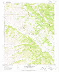
1967 Map of Monarch Peak
USGS Topo · Published 1981About this map
The San Andreas Rift Zone dominates the structural geography of this Central Coast landscape, cutting a visible path between Mustang Ridge and the Peachtree Valley. This 1967 field-checked survey reveals a sparsely populated ranching and agricultural corridor along the San Lorenzo Creek and Peachtree Road. The map provides specific locations for infrastructure supporting this rural economy, such as Water Tanks, Storage Bins, and a Gravel Pit. Notable landmarks include Austin Peak in the north and the Mustang Fire Control Station situated along the rift. To the south, the terrain becomes increasingly complex with numerous named drainage systems, including Tickner Canyon and Bryan Canyon, feeding into the broader Long Valley. This map is a precise record of the Monterey and San Benito county line as it traverses these ridges and alluvial valleys.
Find a feature on this map
30 named features on this map. Tap any name to fly to it.
Don’t see what you’re looking for? This feature index may not catch every label — zoom into the map to look around manually.
Map Details
Editions of this 1967 Monarch Peak Map
3 editions found
Other maps of this area

1912 · San Ardo
USGS Topo · 1:31,680

1915 · Priest Valley
USGS Topo · 1:125,000

1941 · Priest Valley
USGS Topo · 1:62,500

1941 · San Ardo
USGS Topo · 1:62,500

1943 · New Idria
USGS Topo · 1:62,500

1943 · San Ardo
USGS Topo · 1:62,500

1943 · Hernandez Valley
USGS Topo · 1:62,500

1944 · Hernandez Valley
USGS Topo · 1:62,500

1944 · Priest Valley
USGS Topo · 1:62,500

1948 · Santa Cruz
USGS Topo · 1:250,000