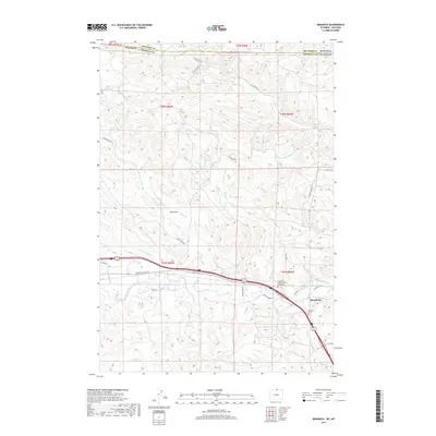
2017 Map of Monarch
USGS Topo · Published 2017About this map
The Tongue River cuts through the southern reaches of this landscape near the border between Wyoming and Montana, anchoring a corridor of historical activity in Sheridan County. The settlement of Monarch and the nearby locale of Kleenburn represent a long-standing presence in this river valley, which is marked by the Evangelical Lutheran Cem of Monarch and the Monarch Cem. This area serves as a transition from the structured river lowlands to the more dissected drainage systems to the north, where numerous creeks such as Little Ash Cr, Ash Cr, and Slater Cr carve through the terrain. Evidence of the local topography is captured in named features like Dan Draw and the various forks of N Dry Cr. The map details a network of rural routes, including Acme Rd and Sheridan Co Rd 93, that connect these communities to the surrounding high plains and seasonal watercourses.
Find a feature on this map
37 named features on this map. Tap any name to fly to it.
Don’t see what you’re looking for? This feature index may not catch every label — zoom into the map to look around manually.
Map Details
Editions of this 2017 Monarch Map
This is the sole edition of this map. No revisions or reprints were ever made.
Other maps of this area

1894 · Rosebud
USGS Topo · 1:125,000

1895 · Dayton
USGS Topo · 1:125,000

1901 · Rosebud
USGS Topo · 1:125,000

1901 · Dayton
USGS Topo · 1:125,000

1909 · Sheridan
USGS Topo · 1:125,000

1911 · Sheridan
USGS Topo · 1:125,000

1954 · Hardin
USGS Topo · 1:250,000

1955 · Sheridan
USGS Topo · 1:250,000

1957 · Hardin
USGS Topo · 1:250,000

1958 · Hardin
USGS Topo · 1:250,000