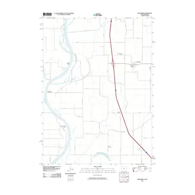
2010 Map of Mondamin
USGS Topo · Published 2010About this map
Mondamin serves as the primary settlement on this western Iowa landscape, situated just east of the wide Missouri River floodplain. The area is defined by a complex network of water management features designed to control the river's drainage, including the Soldier River Cutoff, Burcham Ditch, and the Old Soldier River Ditch. These man-made channels carve through the bottomlands, while natural features like Horseshoe Lake and the prominent Bullard Bluff mark the original character of the terrain.
Find a feature on this map
47 named features on this map. Tap any name to fly to it.
Don’t see what you’re looking for? This feature index may not catch every label — zoom into the map to look around manually.
Map Details
Editions of this 2010 Mondamin Map
This is the sole edition of this map. No revisions or reprints were ever made.
Other maps of this area

1954 · Omaha
USGS Topo · 1:250,000

1955 · Fremont
USGS Topo · 1:250,000

1957 · Fremont
USGS Topo · 1:250,000

1957 · Omaha
USGS Topo · 1:250,000

1958 · Omaha
USGS Topo · 1:250,000

1958 · Fremont
USGS Topo · 1:250,000

1970 · Little Sioux
USGS Topo · 1:24,000
1970 · Missouri Valley
USGS Topo · 1:24,000

1970 · Herman
USGS Topo · 1:24,000

1970 · Mondamin
USGS Topo · 1:24,000