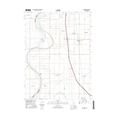
2015 Map of Mondamin
USGS Topo · Published 2015About this map
Mondamin serves as the primary hub of this Harrison County landscape, situated on the edge of the Missouri River floodplains. The complex hydrology of the region is evident in the managed waterways and remnants of the river's former paths, including the Soldier River Cutoff, Burcham Ditch, and the winding Old Soldier River Ditch. Along the western edge, the Missouri River carves through the terrain at Sandy Point Bend, while Bullard Bluff provides a rare point of elevation overlooking the bottomlands. Genealogists will find several burial sites preserved across the township lines, including the Modamin/Noyes Cem, Mondamin Cem, Yutsler Cem, and the solitary Hauger Cem located near Horseshoe Lake. The map reveals a highly structured grid of section lines and rural routes, such as Co Rd K45 and Austin Ave, which facilitate the agricultural economy of the Loess Hills region.
Find a feature on this map
67 named features on this map. Tap any name to fly to it.
Don’t see what you’re looking for? This feature index may not catch every label — zoom into the map to look around manually.
Map Details
Editions of this 2015 Mondamin Map
This is the sole edition of this map. No revisions or reprints were ever made.
Other maps of this area

1954 · Omaha
USGS Topo · 1:250,000

1955 · Fremont
USGS Topo · 1:250,000

1957 · Fremont
USGS Topo · 1:250,000

1957 · Omaha
USGS Topo · 1:250,000

1958 · Omaha
USGS Topo · 1:250,000

1958 · Fremont
USGS Topo · 1:250,000

1970 · Little Sioux
USGS Topo · 1:24,000
1970 · Missouri Valley
USGS Topo · 1:24,000

1970 · Herman
USGS Topo · 1:24,000

1970 · Mondamin
USGS Topo · 1:24,000