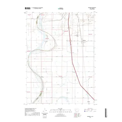
2018 Map of Mondamin
USGS Topo · Published 2018About this map
The Missouri River defines the western edge of this landscape, carving a wide alluvial plain where the Nebraska Iowa state line meanders through shifting watercourses like Sandy Point Bend. To the east, the terrain rises toward Bullard Bluff, overlooking a complex system of drainage and agricultural land management. This 2018 survey reveals an engineered water network, including the Soldier River Cutoff, Burcham Ditch, and Old Soldier River Ditch, which redirect flow across the flat lowlands.
Find a feature on this map
65 named features on this map. Tap any name to fly to it.
Don’t see what you’re looking for? This feature index may not catch every label — zoom into the map to look around manually.
Map Details
Editions of this 2018 Mondamin Map
This is the sole edition of this map. No revisions or reprints were ever made.
Other maps of this area

1954 · Omaha
USGS Topo · 1:250,000

1955 · Fremont
USGS Topo · 1:250,000

1957 · Fremont
USGS Topo · 1:250,000

1957 · Omaha
USGS Topo · 1:250,000

1958 · Omaha
USGS Topo · 1:250,000

1958 · Fremont
USGS Topo · 1:250,000

1970 · Little Sioux
USGS Topo · 1:24,000
1970 · Missouri Valley
USGS Topo · 1:24,000

1970 · Herman
USGS Topo · 1:24,000

1970 · Mondamin
USGS Topo · 1:24,000