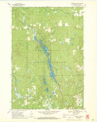
1970 Map of Mondeaux Dam
USGS Topo · Published 1972About this map
The Mondeaux Flowage dominates this 1970 landscape, winding through the heart of the Chequamegon National Forest in Taylor County. Created by the Mondeaux Dam, this water body is the center of a developed recreational corridor featuring numerous sites such as the Lakeview Picnic Area, Eastwood Campground, and Spearhead Point Campground. The map reveals the area's timber and transport history, most notably through the presence of an Old Railroad Grade that cuts through the northern portion of the forest, indicating the path of former logging operations.
Find a feature on this map
29 named features on this map. Tap any name to fly to it.
Don’t see what you’re looking for? This feature index may not catch every label — zoom into the map to look around manually.
Map Details
Editions of this 1970 Mondeaux Dam Map
2 editions found
Other maps of this area

1944 · Ogema
USGS Topo · 1:48,000

1945 · Black River
USGS Topo · 1:48,000

1947 · Ogema
USGS Topo · 1:48,000

1949 · Ogema
USGS Topo · 1:48,000

1949 · Jump River Fire Tower
USGS Topo · 1:48,000

1951 · Lublin
USGS Topo · 1:48,000

1951 · Medford
USGS Topo · 1:48,000

1953 · Rice Lake
USGS Topo · 1:250,000

1959 · Rice Lake
USGS Topo · 1:250,000

1969 · Perkinstown
USGS Topo · 1:24,000