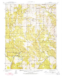
1938 Map of Monegaw Springs
USGS Topo · Published 1977About this map
Monegaw Springs and the surrounding river bluffs are detailed in this 1938 survey, revealing a landscape defined by its rural community institutions and the winding Osage River. The area is densely packed with local landmarks that served the dispersed agricultural population, including the Motley Sch near Motley Cem and the Chalk Level Sch serving the northern settlement of Chalk Level. Geologically, the map captures the transition from the high ridges of the Monegaw and Chalk Level townships down to the river bottoms, with numerous named drainages like Gallinipper Creek and Little Monegaw Creek cutting through the terrain. Notable local history points include the Youngers Lookout high above the river bend and Magnolia Spring near the eastern hills. This record preserves the location of several country churches and schools, such as Kidda Chapel and Red Rock Sch, which formed the social fabric of St. Clair County before modern consolidation.
Find a feature on this map
47 named features on this map. Tap any name to fly to it.
Don’t see what you’re looking for? This feature index may not catch every label — zoom into the map to look around manually.
Map Details
Editions of this 1938 Monegaw Springs Map
2 editions found
Other maps of this area

1886 · Stockton
USGS Topo · 1:125,000

1887 · Clinton
USGS Topo · 1:125,000

1894 · Clinton
USGS Topo · 1:125,000

1937 · Tiffin
USGS Topo · 1:31,680

1938 · Monegaw Springs
USGS Topo · 1:24,000

1938 · Roscoe
USGS Topo · 1:24,000

1938 · Vista
USGS Topo · 1:24,000

1938 · Taberville
USGS Topo · 1:24,000

1939 · Osceola
USGS Topo · 1:24,000

1940 · Taberville
USGS Topo · 1:24,000