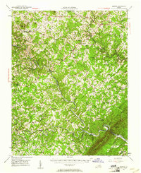
1951 Map of Moneta
USGS Topo · Published 1961About this map
Roanoke River winds through a landscape of deep ridges and steep valleys in this 1951 field-checked survey of the Piedmont region. The map documents a rural economy still shaped by its watercourses and early rail infrastructure, with the Virginian railroad cutting through the terrain via a tunnel near Goodview. This era precedes the full inundation of the Smith Mountain Lake area, showing the river in its natural, meandering channel before the landscape was radically altered by hydroelectric projects.
Find a feature on this map
91 named features on this map. Tap any name to fly to it.
Don’t see what you’re looking for? This feature index may not catch every label — zoom into the map to look around manually.
Map Details
Editions of this 1951 Moneta Map
3 editions found

Other maps of this area

1890 · Roanoke
USGS Topo · 1:125,000

1891 · Roanoke
USGS Topo · 1:125,000

1892 · Lynchburg
USGS Topo · 1:125,000

1921 · Chatham
USGS Topo · 1:48,000

1922 · Callands
USGS Topo · 1:48,000

1923 · Chatham
USGS Topo · 1:62,500

1924 · Callands
USGS Topo · 1:62,500

1925 · Rocky Mount
USGS Topo · 1:48,000

1927 · Rocky Mount
USGS Topo · 1:62,500

1929 · Roanoke
USGS Topo · 1:48,000