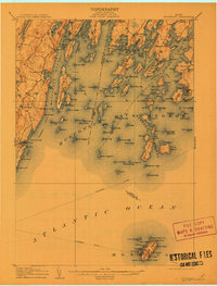
1906 Map of Monhegan
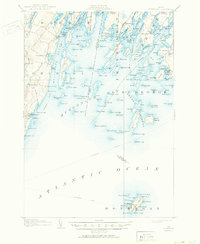
USGS Topo · Published 1950About this map
Monhegan Island sits at the southern edge of this mid-coast maritime landscape, anchored by its namesake Monhegan LH and the rugged contours of Black Head and White Head. The survey details a complex network of coastal commerce and navigation at the start of the twentieth century, tracing the Steamboat Route as it threads through Muscongus Sound and the Georges Islands. Mainland settlements like Port Clyde, New Harbor, and Friendship appear as established fishing and granite hubs, while offshore outposts on Louds Island and Bremen Long Island highlight a period when Maine's larger islands supported year-round communities. Several critical aids to navigation are noted, including the Marshall Pt LH and Franklin LH, marking the treacherous approaches to Muscongus Harbor and the Meduncook River. This map captures a time before the consolidation of coastal industries, when small harbors and family-named landmarks such as Keene Neck and Hooper Island defined the local economy.
Find a feature on this map
81 named features on this map. Tap any name to fly to it.
Don’t see what you’re looking for? This feature index may not catch every label — zoom into the map to look around manually.
Map Details
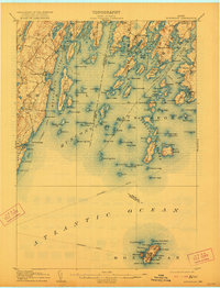
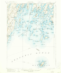
Editions of this 1906 Monhegan Map
5 editions found
Other maps of this area

1893 · Wiscasset
USGS Topo · 1:62,500

1893 · Boothbay
USGS Topo · 1:62,500

1904 · Monhegan
USGS Topo · 1:62,500

1904 · Tenants Harbor
USGS Topo · 1:62,500

1904 · Rockland
USGS Topo · 1:62,500

1906 · Tennant Harbor
USGS Topo · 1:62,500

1906 · Monhegan
USGS Topo · 1:62,500

1906 · Rockland
USGS Topo · 1:62,500

1913 · Waldoboro
USGS Topo · 1:48,000

1915 · Waldoboro
USGS Topo · 1:62,500