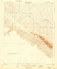
1923 Map of Monocline Ridge
USGS Topo · Published 1943About this map
Monocline Ridge dominates the landscape in this early 1920s survey of Fresno County, where the sharp transition from the central valley floor to the uplifted Tumey Hills is captured in fine topographic detail. The terrain is defined by the drainage of Tumey Gulch, a seasonal watercourse that cuts through the ridgeline. Cultural features are sparse, reflecting the rural character of the era, yet significant landmarks like the Tumey Gulch School indicate a small, established community of ranching or farming families in the foothills. The presence of an Oil Pumping Station on the lower plains suggests the early industrial footprint of California's petroleum industry as it expanded across the San Joaquin Valley. This 1:31,680 scale map provides a much more granular view of the local topography than the earlier 1908-1911 Panoche quadrangle from which this specific area was derived.
Find a feature on this map
6 named features on this map. Tap any name to fly to it.
Don’t see what you’re looking for? This feature index may not catch every label — zoom into the map to look around manually.
Map Details
Editions of this 1923 Monocline Ridge Map
3 editions found
Other maps of this area

1912 · Coalinga
USGS Topo · 1:125,000

1913 · Panoche
USGS Topo · 1:125,000

1915 · Priest Valley
USGS Topo · 1:125,000

1921 · Tierra Loma School
USGS Topo · 1:31,680

1922 · Tufts Ranch
USGS Topo · 1:31,680

1922 · Chaney Ranch
USGS Topo · 1:31,680

1923 · Levis
USGS Topo · 1:31,680

1923 · Tierra Loma School
USGS Topo · 1:31,680

1923 · Monocline Ridge
USGS Topo · 1:31,680

1943 · New Idria
USGS Topo · 1:62,500