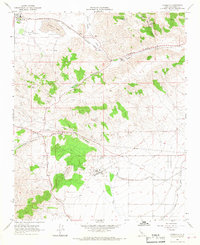
1966 Map of Monolith
USGS Topo · Published 1967About this map
The industrial and transit-heavy corridor of the Tehachapi Valley is meticulously detailed in this mid-1960s study, centered on the settlement of Monolith. The landscape is defined by the critical infrastructure of the era, where the Atchison Topeka and Santa Fe and Southern Pacific railroads converge near Eric and Cameron. These rail lines follow the natural grades through Tehachapi Pass alongside early infrastructure like the Los Angeles Aqueduct and numerous high-pressure pipelines. Resource extraction is a primary driver of local development, evidenced by several quarries, a Borrow Pit, and Limestone deposits near the valley floor. To the east, the terrain transitions into the steep ridges of Pajuela Peak and the drainage of Water Canyon Creek, while the ephemeral Proctor Lake occupies the valley's western basin.
Find a feature on this map
33 named features on this map. Tap any name to fly to it.
Don’t see what you’re looking for? This feature index may not catch every label — zoom into the map to look around manually.
Map Details
Editions of this 1966 Monolith Map
3 editions found
Other maps of this area

1915 · Elizabeth Lake
USGS Topo · 1:125,000

1915 · Mojave
USGS Topo · 1:125,000

1917 · Elizabeth Lake
USGS Topo · 1:125,000

1943 · Rosamond
USGS Topo · 1:62,500

1943 · Tehachapi
USGS Topo · 1:62,500

1943 · Mojave
USGS Topo · 1:62,500

1943 · Willow Springs
USGS Topo · 1:62,500

1947 · Mojave
USGS Topo · 1:24,000

1947 · Soledad Mountain
USGS Topo · 1:24,000

1948 · Bakersfield
USGS Topo · 1:250,000