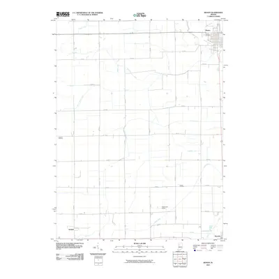
2010 Map of Monon
USGS Topo · Published 2010About this map
Monon anchors the northeastern corner of this White County landscape, where the grid of rural roads meets the intricate network of agricultural drainage channels that define the region's hydrology. The map details a transition from the structured residential blocks of Monon and Reynolds to a vast expanse of farmland crisscrossed by named watercourses like Hoagland Ditch and Blanchard Ditch. These man-made and improved natural channels, including Honey Creek, reveal the intensive engineering required to manage the prairie’s water table for cultivation. Scattered throughout the quadrangle are vital markers of early settlement and community life, such as Palestine Cemetery and Swisher Cemetery, alongside more modern infrastructure like Klopfenstein Airport. Near the southern edge, the small community of Seafield sits along the road network, illustrating the persistent, quiet presence of these railway-era hamlets within the modern Indiana agricultural heartland.
Find a feature on this map
37 named features on this map. Tap any name to fly to it.
Don’t see what you’re looking for? This feature index may not catch every label — zoom into the map to look around manually.
Map Details
Editions of this 2010 Monon Map
This is the sole edition of this map. No revisions or reprints were ever made.
Other maps of this area

1953 · Danville
USGS Topo · 1:250,000

1955 · Danville
USGS Topo · 1:250,000

1956 · Danville
USGS Topo · 1:250,000

1962 · Monticello South
USGS Topo · 1:24,000

1962 · Templeton NE
USGS Topo · 1:24,000

1962 · Monon NE
USGS Topo · 1:24,000

1962 · Brookston NW
USGS Topo · 1:24,000

1962 · Monon
USGS Topo · 1:24,000

1962 · Monticello North
USGS Topo · 1:24,000
1962 · Francesville
USGS Topo · 1:24,000