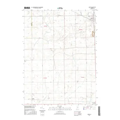
2016 Map of Monon
USGS Topo · Published 2016About this map
Monon anchors the northeastern corner of this White County landscape, where the town's grid meets an extensive network of drainage infrastructure essential to Indiana's agricultural history. The territory is defined by an intricate system of man-made waterways, including Blanchard Ditch, Robinson Ditch, and McKillip Ditch, which redirect water across the flat terrain of the Jasper and White County line. These channels, along with Honey Creek, illustrate the engineered nature of the regional watershed. To the south, the settlements of Seafield and Reynolds sit along the lower edge of the survey, connected by a rigid section-line road system. Local history is preserved in several rural burial grounds scattered across the townships, such as Monon Cemetery, the remote Palestine Cemetery to the west, and Swisher Cemetery located near the center of the quadrangle.
Find a feature on this map
39 named features on this map. Tap any name to fly to it.
Don’t see what you’re looking for? This feature index may not catch every label — zoom into the map to look around manually.
Map Details
Editions of this 2016 Monon Map
This is the sole edition of this map. No revisions or reprints were ever made.
Other maps of this area

1953 · Danville
USGS Topo · 1:250,000

1955 · Danville
USGS Topo · 1:250,000

1956 · Danville
USGS Topo · 1:250,000

1962 · Monticello South
USGS Topo · 1:24,000

1962 · Templeton NE
USGS Topo · 1:24,000

1962 · Monon NE
USGS Topo · 1:24,000

1962 · Brookston NW
USGS Topo · 1:24,000

1962 · Monon
USGS Topo · 1:24,000

1962 · Monticello North
USGS Topo · 1:24,000
1962 · Francesville
USGS Topo · 1:24,000