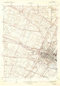
1942 Map of Monroe
USGS Topo · Published 1942About this map
The City of Monroe is the central focus of this 1940s survey, showing a dense industrial and transport hub along the Raisin River. As the county seat, it features critical social infrastructure like the County Infirmary, St Marys Academy, and Soldiers and Sailors Park. The surrounding landscape is a complex network of small drainage channels like Mason Run and Bates Drain, vital for the agricultural and development needs of Frenchtown and Raisinville townships.
Find a feature on this map
115 named features on this map. Tap any name to fly to it.
Don’t see what you’re looking for? This feature index may not catch every label — zoom into the map to look around manually.
Map Details
Editions of this 1942 Monroe Map
2 editions found
Other maps of this area

1902 · Ypsilanti
USGS Topo · 1:62,500

1904 · Ann Arbor
USGS Topo · 1:125,000

1906 · Ypsilanti
USGS Topo · 1:62,500

1906 · Romulus
USGS Topo · 1:62,500

1908 · Ann Arbor
USGS Topo · 1:125,000

1912 · Monroe
USGS Topo · 1:62,500

1912 · Dundee
USGS Topo · 1:62,500

1914 · Monroe
USGS Topo · 1:62,500

1926 · Dundee
USGS Topo · 1:62,500

1927 · Monroe
USGS Topo · 1:31,680
Featured Places
- Frenchtown Charter Township, MI
- Monroe, MI
- Monroe Charter Township, MI
- South Monroe, Monroe Charter Township
- Raisinville Township, MI