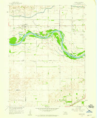
1958 Map of Monroe
USGS Topo · Published 1959About this map
Monroe and Oconee serve as the primary rail-oriented settlements in this Platte County landscape during the late 1950s. The region is defined by the complex water management systems of the Loup River, featuring the prominent Loup River Canal protected by a series of levees and a spoil bank. This infrastructure supported local industry, evidenced by the Powerplant located north of the river and a Gravel Pit along the banks.
Find a feature on this map
22 named features on this map. Tap any name to fly to it.
Don’t see what you’re looking for? This feature index may not catch every label — zoom into the map to look around manually.
Map Details
Editions of this 1958 Monroe Map
2 editions found
Other maps of this area

1896 · Stromsburg
USGS Topo · 1:125,000

1899 · David City
USGS Topo · 1:125,000

1955 · Fremont
USGS Topo · 1:250,000

1957 · Fremont
USGS Topo · 1:250,000

1958 · Fremont
USGS Topo · 1:250,000

1958 · Genoa
USGS Topo · 1:24,000

1958 · Monroe
USGS Topo · 1:24,000

1958 · Duncan
USGS Topo · 1:24,000

1958 · Columbus SW
USGS Topo · 1:24,000

1958 · Silver Creek SE
USGS Topo · 1:24,000