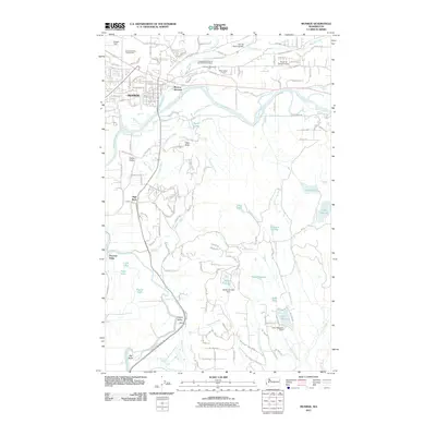
2011 Map of Monroe
USGS Topo · Published 2011About this map
Monroe sits at the confluence of the Skykomish River and Woods Creek, serving as a central hub for the surrounding agricultural and river valleys. This early 21st-century landscape is defined by its transition from the dense residential grid of the town center to the sprawling rural acreage of Tualco Valley and Cherry Valley. The map highlights important community landmarks, including the Evergreen State Fairgrounds and the Independent Order of Odd Fellows Cemetery. To the south, the Snoqualmie River meanders toward the Big Bend, while the modern-day conversion of old rail corridors is evidenced by the Snoqualmie Valley Trl. Notable water features such as Johnsons Swamp and Trestle Swamp reflect the low-lying, marshy character of the terrain between the river systems, dotted with small aviation sites like Firstair Field and the Van De Plasch Airport.
Find a feature on this map
66 named features on this map. Tap any name to fly to it.
Don’t see what you’re looking for? This feature index may not catch every label — zoom into the map to look around manually.
Map Details
Editions of this 2011 Monroe Map
This is the sole edition of this map. No revisions or reprints were ever made.
Other maps of this area

1895 · Snohomish
USGS Topo · 1:125,000

1897 · Seattle
USGS Topo · 1:125,000

1921 · Sultan
USGS Topo · 1:125,000

1923 · Sultan
USGS Topo · 1:125,000

1944 · Everett
USGS Topo · 1:62,500

1950 · Redmond
USGS Topo · 1:24,000

1953 · Sultan
USGS Topo · 1:24,000

1953 · Lake Joy
USGS Topo · 1:24,000

1953 · Monroe
USGS Topo · 1:24,000
1953 · Maltby
USGS Topo · 1:24,000