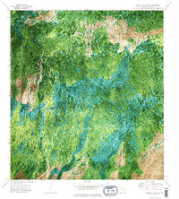
1972 Map of Monroe Station NE
USGS Topo · Published 1984About this map
Osceola Strand dominates the central portion of this 1970s orthophotomap, revealing the intricate water and vegetation patterns of the Florida Everglades. This specialized photographic survey, prepared from 1971 aerial imagery, provides a clear visual record of the wet prairies and cypress strands before significant modern alterations. To the north, the terrain opens into Lost Dog Prairie and Buckskin Prairie, distinct clearings in the dense subtropical growth. Human presence is sparse, marked primarily by the linear path of Monument Road and a remote Landing Strip in the northeast. The map captures the raw intersection of the Big Cypress swamp environment with minimal transit infrastructure, documenting the natural drainage and vegetative boundaries of Collier County in this era.
Find a feature on this map
8 named features on this map. Tap any name to fly to it.
Don’t see what you’re looking for? This feature index may not catch every label — zoom into the map to look around manually.
Map Details
Editions of this 1972 Monroe Station NE Map
3 editions found
Other maps of this area

1956 · Miami
USGS Topo · 1:250,000

1956 · West Palm Beach
USGS Topo · 1:250,000

1957 · West Palm Beach
USGS Topo · 1:250,000

1958 · West Palm Beach
USGS Topo · 1:250,000

1958 · Miami
USGS Topo · 1:250,000

1972 · Monroe Station NE
USGS Topo · 1:24,000

1972 · Burns Lake
USGS Topo · 1:24,000

1973 · Gator Hook Swamp
USGS Topo · 1:24,000

1973 · Fiftymile Bend
USGS Topo · 1:24,000

1973 · North Of Fiftymile Bend
USGS Topo · 1:24,000