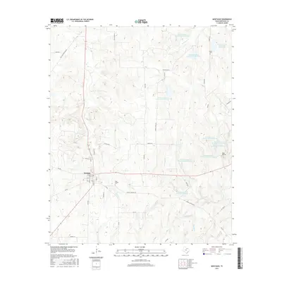
2016 Map of Montague
USGS Topo · Published 2016About this map
Montague serves as the focal point of this North Texas survey, exhibiting a classic grid layout with streets such as Main St, Franklin St, and Grand St. The surrounding landscape is defined by an extensive water management system, characterized by numerous conservation basins including Soil Conservation Service Debris Basin 115 and Soil Conservation Service Site 7 Reservoir. These structures are integrated into a drainage network comprising Salt Creek, West Farmers Creek, and Steelmans Branch.
Find a feature on this map
53 named features on this map. Tap any name to fly to it.
Don’t see what you’re looking for? This feature index may not catch every label — zoom into the map to look around manually.
Map Details
Editions of this 2016 Montague Map
This is the sole edition of this map. No revisions or reprints were ever made.
Other maps of this area

1905 · Montague
USGS Topo · 1:125,000

1954 · Sherman
USGS Topo · 1:250,000

1958 · Sherman
USGS Topo · 1:250,000

1960 · Buzzard Roost Knob
USGS Topo · 1:24,000

1961 · Saint Jo
USGS Topo · 1:24,000

1961 · Salona
USGS Topo · 1:24,000

1961 · Montague
USGS Topo · 1:24,000

1961 · Bowie
USGS Topo · 1:24,000
1961 · Forestburg
USGS Topo · 1:24,000
1968 · Bonita
USGS Topo · 1:24,000