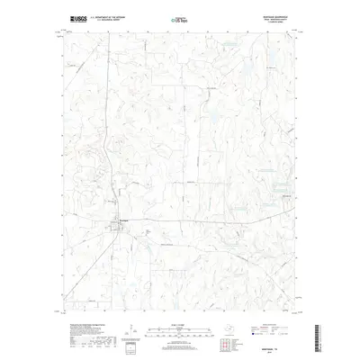
2019 Map of Montague
USGS Topo · Published 2019About this map
Montague serves as the central hub for this North Texas landscape, where the grid of the town center meets the winding tributaries of the Red River watershed. The terrain is defined by the drainages of Salt Cr, Ritchie Cr, and W Farmers Cr, which cut through the elevation toward the north and east. This 2019 survey documents a significant network of water management features, including Soil Conservation Service Debris Basin 110 and several others clustered near Blue Mound. For local historians and genealogists, the map preserves the locations of Saint Williams Cem and Starkey Cem, alongside road names that hint at earlier community landmarks, such as Aurelia School Rd, Dixie School Rd, and Rock Springs School Rd. The presence of the PR Oil Lease reflects the region's ongoing intersection of agricultural land use and mineral extraction.
Find a feature on this map
48 named features on this map. Tap any name to fly to it.
Don’t see what you’re looking for? This feature index may not catch every label — zoom into the map to look around manually.
Map Details
Editions of this 2019 Montague Map
This is the sole edition of this map. No revisions or reprints were ever made.
Other maps of this area

1905 · Montague
USGS Topo · 1:125,000

1954 · Sherman
USGS Topo · 1:250,000

1958 · Sherman
USGS Topo · 1:250,000

1960 · Buzzard Roost Knob
USGS Topo · 1:24,000

1961 · Saint Jo
USGS Topo · 1:24,000

1961 · Salona
USGS Topo · 1:24,000

1961 · Montague
USGS Topo · 1:24,000

1961 · Bowie
USGS Topo · 1:24,000
1961 · Forestburg
USGS Topo · 1:24,000
1968 · Bonita
USGS Topo · 1:24,000