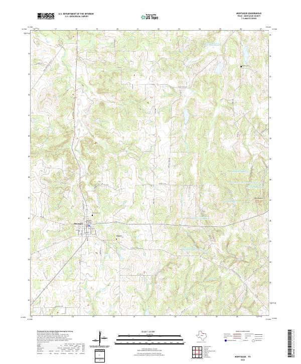
2022 Map of Montague
USGS Topo · Published 2022About this map
The Montague County Courthouse serves as the focal point of this North Texas seat, where the grid of Montague transitions into a landscape of winding country lanes and vital water conservation sites. The town's layout, centered on Main St and Salt St, is flanked by legacy sites including the Montague Cem and the Montague Catholic Cem. Beyond the town center, the terrain is marked by a series of erosion control structures, such as Soil Conservation Service Debris Basin 112 and Soil Conservation Service Debris Basin 110, illustrating 21st-century land management along the tributaries of Salt Cr and W Farmers Cr. Notable elevation markers like Blue Mound rise above a network of family-named roads, including Nobile Rd and Fenoglio Rd, while older landmarks like Dixie School Rd hint at the rural educational history of the county.
Find a feature on this map
48 named features on this map. Tap any name to fly to it.
Don’t see what you’re looking for? This feature index may not catch every label — zoom into the map to look around manually.
Map Details
Editions of this 2022 Montague Map
This is the sole edition of this map. No revisions or reprints were ever made.
Other maps of this area

1905 · Montague
USGS Topo · 1:125,000

1954 · Sherman
USGS Topo · 1:250,000

1958 · Sherman
USGS Topo · 1:250,000

1960 · Buzzard Roost Knob
USGS Topo · 1:24,000

1961 · Saint Jo
USGS Topo · 1:24,000

1961 · Salona
USGS Topo · 1:24,000

1961 · Montague
USGS Topo · 1:24,000

1961 · Bowie
USGS Topo · 1:24,000
1961 · Forestburg
USGS Topo · 1:24,000
1968 · Bonita
USGS Topo · 1:24,000