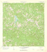
1960 Map of Monte Guilarte
USGS Topo · Published 1962About this map
Monte Guilarte and the surrounding central highlands of Puerto Rico are defined by a complex agrarian economy centered on traditional coffee estates. This 1960 revision by Francisco Lizardi and the Department of Public Works illustrates an intricate network of haciendas, including Hacienda Monserrate, Hacienda Vilella, and Hacienda Santa Maria, which served as the primary social and economic nodes for the rural population. The landscape is deeply incised by the headwaters of the Río Blanco and Río Grande, with the settlement of Castañer serving as a significant mountain crossroads.
Find a feature on this map
148 named features on this map. Tap any name to fly to it.
Don’t see what you’re looking for? This feature index may not catch every label — zoom into the map to look around manually.
Map Details
Editions of this 1960 Monte Guilarte Map
4 editions found
Other maps of this area

1937 · Sabana Grande
USGS Topo · 1:25,000

1938 · San Sebastian
USGS Topo · 1:20,000

1941 · San Sebastian
USGS Topo · 1:30,000

1941 · Sabana Grande
USGS Topo · 1:30,000

1946 · Maricao
USGS Topo · 1:30,000

1946 · Utuado
USGS Topo · 1:30,000

1946 · Bayaney
USGS Topo · 1:30,000

1946 · Yauco
USGS Topo · 1:30,000

1946 · Monte Guilarte
USGS Topo · 1:30,000

1946 · Penuelas
USGS Topo · 1:30,000
Featured Places
- Sector Lombrices, Adjuntas
- Sector Los Pagán, Adjuntas
- Sector Palo Seco, Adjuntas
- Sector Jiménez Santiago, Adjuntas
- Sector Titulo Quinto, Adjuntas