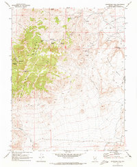
1970 Map of Montezuma Peak
USGS Topo · Published 1973About this map
Montezuma and Gemfield anchor this 1970 snapshot of Esmeralda County, showing a landscape defined by mining history and the vital necessity of desert water sources. The Montezuma Range, rising to Montezuma Peak, dominates the west, while the eastern flats are characterized by Malpais Mesa and the Goldfield Hills. The abundance of named water features like Brickyard Spring, Dago Joe Spring, and Slaughterhouse Spring speaks to the region's reliance on these isolated points for ranching and extraction efforts.
Find a feature on this map
33 named features on this map. Tap any name to fly to it.
Don’t see what you’re looking for? This feature index may not catch every label — zoom into the map to look around manually.
Map Details
Editions of this 1970 Montezuma Peak Map
2 editions found
Other maps of this area

1908 · Lida
USGS Topo · 1:250,000

1913 · Lida
USGS Topo · 1:250,000

1945 · Goldfield
USGS Topo · 1:125,000

1952 · Mud Lake
USGS Topo · 1:62,500

1952 · Goldfield
USGS Topo · 1:62,500

1954 · Goldfield
USGS Topo · 1:250,000

1955 · Goldfield
USGS Topo · 1:250,000

1958 · Goldfield
USGS Topo · 1:250,000

1962 · Goldfield
USGS Topo · 1:250,000
1970 · Montezuma Peak SW
USGS Topo · 1:24,000