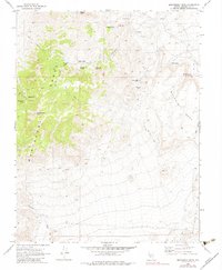
1970 Map of Montezuma Peak
USGS Topo · Published 1983About this map
The Montezuma Range dominates this corner of Esmeralda County, reflecting a landscape defined by mining prospecting and high-desert water sources. Surveyed in 1970, the map documents industrial traces such as the Nevada Eagle Mine, a Drill Hole, and various prospects scattered across the arid terrain. The presence of Petroglyphs near Indian Canyon points to ancient human activity, while names like Dago Joe Spring, Slaughterhouse Spring, and Brickyard Spring reveal the 19th and early 20th-century ranching and freighting history. Settlement is sparse, represented by the small community of Gemfield and the historic site of Montezuma. A complex network of a Jeep Trail and a Pack Trail navigate the high elevations of Montezuma Peak and the flat expanse of Malpais Mesa, showing how modern exploration followed older, established routes through the Goldfield Hills.
Find a feature on this map
38 named features on this map. Tap any name to fly to it.
Don’t see what you’re looking for? This feature index may not catch every label — zoom into the map to look around manually.
Map Details
Editions of this 1970 Montezuma Peak Map
2 editions found
Other maps of this area

1908 · Lida
USGS Topo · 1:250,000

1913 · Lida
USGS Topo · 1:250,000

1945 · Goldfield
USGS Topo · 1:125,000

1952 · Mud Lake
USGS Topo · 1:62,500

1952 · Goldfield
USGS Topo · 1:62,500

1954 · Goldfield
USGS Topo · 1:250,000

1955 · Goldfield
USGS Topo · 1:250,000

1958 · Goldfield
USGS Topo · 1:250,000

1962 · Goldfield
USGS Topo · 1:250,000
1970 · Montezuma Peak SW
USGS Topo · 1:24,000