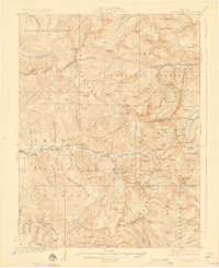
1926 Map of Montezuma
USGS Topo · Published 1926About this map
The Continental Divide serves as the backbone of this high-altitude survey, delineating the borders of the Arapaho National Forest, Pike National Forest, and Leadville National Forest during the mid-1920s. The landscape is defined by its industrial activity, with concentrated mining operations such as the Waldorf Mine, Stevens Mine, and the Golden Belt Tunnel tunneling into the peaks of the Williams River Mountains and Mc Clellan Mountain. These sites were supported by small, specialized mountain settlements like Montezuma and Tiger, which sat at the intersections of rugged gulches and the upper reaches of the Snake River.
Find a feature on this map
126 named features on this map. Tap any name to fly to it.
Don’t see what you’re looking for? This feature index may not catch every label — zoom into the map to look around manually.
Map Details
Editions of this 1926 Montezuma Map
3 editions found

Other maps of this area

1889 · Leadville
USGS Topo · 1:125,000

1891 · Leadville
USGS Topo · 1:125,000

1903 · Georgetown
USGS Topo · 1:62,500

1905 · Central City
USGS Topo · 1:62,500

1905 · Georgetown
USGS Topo · 1:62,500

1910 · Central City
USGS Topo · 1:62,500

1912 · Central City
USGS Topo · 1:62,500

1924 · Montezuma
USGS Topo · 1:62,500

1924 · Fraser
USGS Topo · 1:62,500

1926 · Fraser
USGS Topo · 1:62,500