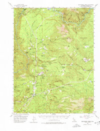
1956 Map of Montgomery Creek
USGS Topo · Published 1978About this map
The Pit River carves a deep path through northern California, flanked by the Shasta National Forest and Lassen National Forest. In the mid-1950s, this landscape was a hub of hydroelectric activity, anchored by the Pit Four Reservoir and infrastructure like the Pit No 5 Powerhouse and Pit No 4 Dam. Cultural markers of the era include the Montgomery Creek Indian Rancheria and Roaring Creek Indian Rancheria, alongside several education centers marked as no longer in use, such as Pineland School (Aband) and Mountain Sch (Aband). Local life centered around small settlements like Bush Bar and Wengler, while timber and transit are evidenced by the Hillcrest Fire Control Sta and the Fender Ferry Road. The map provides a detailed view of the region's topography, from the heights of Chalk Mountain to the depths of Iron Canyon.
Find a feature on this map
102 named features on this map. Tap any name to fly to it.
Don’t see what you’re looking for? This feature index may not catch every label — zoom into the map to look around manually.
Map Details
Editions of this 1956 Montgomery Creek Map
3 editions found
Other maps of this area

1886 · Lassen Peak
USGS Topo · 1:250,000

1886 · Modoc Lava Bed
USGS Topo · 1:250,000

1886 · Shasta
USGS Topo · 1:250,000

1890 · Red Bluff
USGS Topo · 1:250,000

1892 · Modoc Lava-Bed
USGS Topo · 1:250,000

1892 · Lassen Peak
USGS Topo · 1:250,000

1894 · Lassen Peak
USGS Topo · 1:250,000

1894 · Red Bluff
USGS Topo · 1:250,000

1894 · Shasta
USGS Topo · 1:250,000

1901 · Redding
USGS Topo · 1:125,000