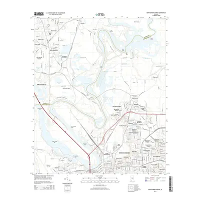
2014 Map of Montgomery North
USGS Topo · Published 2014About this map
The Alabama River Pky and the winding course of the Alabama River define this landscape north of the state capital, where the borders of Elmore and Montgomery counties meet. The river's serpentine path creates distinct landforms like Big Bend, Gun Island, and Mud Island, alongside numerous backwater features such as Cooter Pond and Dorminey Pond. Development is concentrated in several established residential districts including Chisholm, Boylston, and Sheridan Heights, while the northern portion shows more open terrain around Five Points and Rose Hill.
Find a feature on this map
94 named features on this map. Tap any name to fly to it.
Don’t see what you’re looking for? This feature index may not catch every label — zoom into the map to look around manually.
Map Details
Editions of this 2014 Montgomery North Map
This is the sole edition of this map. No revisions or reprints were ever made.
Other maps of this area

1901 · Wetumpka
USGS Topo · 1:125,000

1901 · Wetumpka
USGS Topo · 1:62,500

1903 · Wetumpka
USGS Topo · 1:125,000

1927 · Montgomery
USGS Topo · 1:48,000

1930 · Montgomery
USGS Topo · 1:62,500

1953 · Montgomery
USGS Topo · 1:250,000

1956 · Montgomery
USGS Topo · 1:250,000

1957 · Montgomery
USGS Topo · 1:250,000

1958 · Montgomery
USGS Topo · 1:62,500

1958 · Montgomery North
USGS Topo · 1:24,000