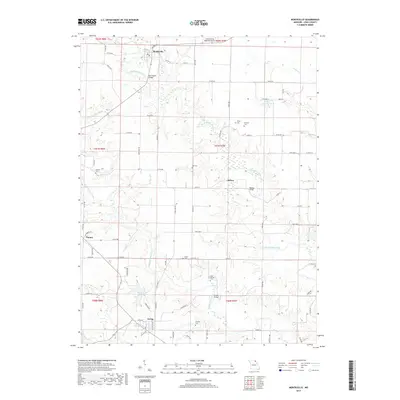
2017 Map of Monticello
USGS Topo · Published 2017About this map
The North Fabius River and Middle Fabius River wind through the heart of Lewis County, creating a rolling agricultural landscape defined by watercourses and small rural centers. The northern settlement of Monticello serves as a focal point near the Monticello Bridge, while Ewing anchors the southern portion of the map near Ewing Lake. This 2017 survey reveals a deeply rooted community structure, evidenced by numerous family-named burial grounds such as Briscoe Cem, Cason Cem, and Garnett Cem scattered among the farmsteads. The local infrastructure is further marked by the Lewis County Regional Airport and several river crossings, including the Weston Bridge and Steele Bridge. The spatial arrangement of towns like Tolona and Sellers illustrates the persistent rural character of this Northeast Missouri region, where local transport still relies on a network of state highways and county roads like State Hwy BB.
Find a feature on this map
87 named features on this map. Tap any name to fly to it.
Don’t see what you’re looking for? This feature index may not catch every label — zoom into the map to look around manually.
Map Details
Editions of this 2017 Monticello Map
This is the sole edition of this map. No revisions or reprints were ever made.
Other maps of this area

1903 · Kahoka
USGS Topo · 1:125,000

1903 · Palmyra
USGS Topo · 1:125,000

1948 · Quincy
USGS Topo · 1:250,000

1949 · Durham
USGS Topo · 1:24,000

1949 · Maywood
USGS Topo · 1:24,000
1950 · Maywood
USGS Topo · 1:24,000

1950 · Durham
USGS Topo · 1:24,000

1950 · La Grange
USGS Topo · 1:24,000

1950 · Benjamin
USGS Topo · 1:24,000

1950 · Williamstown
USGS Topo · 1:24,000