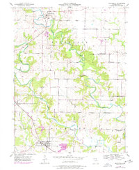
1950 Map of Monticello
USGS Topo · Published 1977About this map
Monticello serves as the focal point of this Lewis County landscape, situated where the North Fabius River winds through the northern hills. The settlement pattern reflects a mid-century agricultural community organized around township lines, with Dickerson and Highland defining the local jurisdictions. The map captures a high density of small-scale rural infrastructure, including a string of family cemeteries such as Finley Cem and Garnett Cem, which provide valuable data points for genealogical research in the region.
Find a feature on this map
24 named features on this map. Tap any name to fly to it.
Don’t see what you’re looking for? This feature index may not catch every label — zoom into the map to look around manually.
Map Details
Editions of this 1950 Monticello Map
This is the sole edition of this map. No revisions or reprints were ever made.
Other maps of this area

1903 · Kahoka
USGS Topo · 1:125,000

1903 · Palmyra
USGS Topo · 1:125,000

1948 · Quincy
USGS Topo · 1:250,000

1949 · Durham
USGS Topo · 1:24,000

1949 · Maywood
USGS Topo · 1:24,000
1950 · Maywood
USGS Topo · 1:24,000

1950 · Durham
USGS Topo · 1:24,000

1950 · La Grange
USGS Topo · 1:24,000

1950 · Benjamin
USGS Topo · 1:24,000

1950 · Williamstown
USGS Topo · 1:24,000