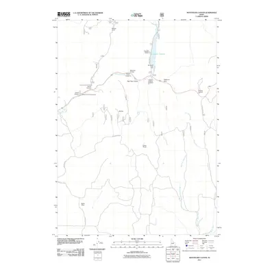
2011 Map of Montpelier Canyon
USGS Topo · Published 2011About this map
The Preuss Range dominates this corner of Bear Lake County, where high-altitude drainages and technical forest infrastructure define the landscape. Water management is a primary theme of the terrain, centered on the Montpelier Reservoir and the Montpelier Creek Dam. The network of canyons and draws, including Aeggetter Hollow and West Elbow Hollow, illustrates the complex hydrology that feeds into Montpelier Creek and the West Fork Sheep Creek.
Find a feature on this map
28 named features on this map. Tap any name to fly to it.
Don’t see what you’re looking for? This feature index may not catch every label — zoom into the map to look around manually.
Map Details
Editions of this 2011 Montpelier Canyon Map
This is the sole edition of this map. No revisions or reprints were ever made.
Other maps of this area

1909 · Montpelier
USGS Topo · 1:125,000

1911 · Montpelier
USGS Topo · 1:125,000

1955 · Preston
USGS Topo · 1:250,000

1958 · Preston
USGS Topo · 1:250,000

1962 · Preston
USGS Topo · 1:250,000

1967 · Montpelier
USGS Topo · 1:24,000

1967 · Dingle
USGS Topo · 1:24,000
1970 · Georgetown
USGS Topo · 1:24,000
1970 · Border
USGS Topo · 1:24,000
1970 · Montpelier Canyon
USGS Topo · 1:24,000