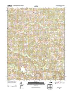
2013 Map of Montpelier
USGS Topo · Published 2013About this map
The South Anna River and the Newfound River define the hydrography of this Hanover County landscape, where rural settlements and crossroads remain the primary anchors. This 2013 survey illustrates a network of historic thoroughfares such as the Jefferson Hwy and Mountain Rd, which connect established communities like Montpelier and Mabelton. The region is characterized by significant wetlands and drainages, including Wolf Swamp, Jones Swamp, and Colley Swamp, which influence the local topography and land use patterns. Scattered throughout the quadrangle are small community centers like Gouldin, Goodall, and Vontay, as well as named junctions like Goshen Cross Road and Jones Corner. These intersections often represent historical points of commerce and local gathering. Notable landmarks such as Big Rock near the riverbanks and the numerous creeks like Taylors Creek and Cedar Cr provide specific geographic markers for those tracing local land tracts or genealogical roots.
Find a feature on this map
96 named features on this map. Tap any name to fly to it.
Don’t see what you’re looking for? This feature index may not catch every label — zoom into the map to look around manually.
Map Details
Editions of this 2013 Montpelier Map
This is the sole edition of this map. No revisions or reprints were ever made.
Other maps of this area

1890 · Goochland
USGS Topo · 1:125,000

1892 · Goochland
USGS Topo · 1:125,000

1936 · Glen Allen
USGS Topo · 1:24,000

1941 · Glen Allen
USGS Topo · 1:31,680

1942 · Buckner
USGS Topo · 1:24,000

1942 · Beaverdam
USGS Topo · 1:24,000

1943 · Mabelton
USGS Topo · 1:31,680
1943 · Hanover Academy
USGS Topo · 1:31,680

1943 · Perkinsville
USGS Topo · 1:31,680
1943 · Buckner
USGS Topo · 1:31,680