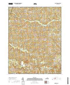
2019 Map of Montpelier
USGS Topo · Published 2019About this map
Montpelier serves as the central hub of this rural Hanover County landscape, where the road network radiates out toward smaller crossroads and settlements. The terrain is defined by the winding course of the Newfound River in the north and the South Anna River in the south, with numerous tributaries like Cattail Cr and Taylors Cr carving through the wooded countryside. The map documents a blend of old agricultural homesteads and newer residential lanes, such as Parrish Farm Rd and Connie Hall Rd. Genealogists and local historians can locate specific landmarks including Saint Peters Cem near Goodall, and trace the proximity of the Louisa County line near Mabelton. The presence of features like Jones Swamp and Wolf Swamp illustrates the low-lying, water-rich nature of the Virginia Piedmont in this region, while names like Goshen Cross Road and Vontay highlight the enduring character of these historic rural communities.
Find a feature on this map
128 named features on this map. Tap any name to fly to it.
Don’t see what you’re looking for? This feature index may not catch every label — zoom into the map to look around manually.
Map Details
Editions of this 2019 Montpelier Map
This is the sole edition of this map. No revisions or reprints were ever made.
Other maps of this area

1890 · Goochland
USGS Topo · 1:125,000

1892 · Goochland
USGS Topo · 1:125,000

1936 · Glen Allen
USGS Topo · 1:24,000

1941 · Glen Allen
USGS Topo · 1:31,680

1942 · Buckner
USGS Topo · 1:24,000

1942 · Beaverdam
USGS Topo · 1:24,000

1943 · Mabelton
USGS Topo · 1:31,680
1943 · Hanover Academy
USGS Topo · 1:31,680

1943 · Perkinsville
USGS Topo · 1:31,680
1943 · Buckner
USGS Topo · 1:31,680