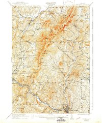
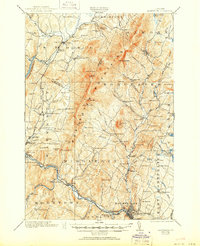
1921 Map of Montpelier
USGS Topo · Published 1943About this map
The Worcester Mountains dominate this central Vermont landscape, forming a prominent north-south ridge between the Waterbury River and the Winooski River. In the years following the Great War, the region's economy relied on a network of small upland settlements and valley towns connected by the Central Vermont and M and W R R railroads. Industry is marked by a Talc Mine near Waterbury, while the rural character is evident in the dozens of district schools, such as the Pucker Street School and Hampshire Hill School, that served isolated farming pockets. The state capital, Montpelier, sits at the southern confluence of the Winooski and Dog R, surrounded by historically significant grounds like Green Mountain Cemetery and the industrial activity at Montpelier Junction.
Find a feature on this map
122 named features on this map. Tap any name to fly to it.
Don’t see what you’re looking for? This feature index may not catch every label — zoom into the map to look around manually.
Map Details
Editions of this 1921 Montpelier Map
6 editions found
Other maps of this area

1919 · Lincoln Mountain
USGS Topo · 1:62,500

1919 · Montpelier
USGS Topo · 1:62,500

1920 · Lincoln Mountain
USGS Topo · 1:48,000

1921 · Richmond
USGS Topo · 1:48,000

1921 · Lincoln Mountain
USGS Topo · 1:62,500

1921 · Montpelier
USGS Topo · 1:62,500

1922 · Barre
USGS Topo · 1:48,000

1924 · Barre
USGS Topo · 1:62,500

1924 · Camels Hump
USGS Topo · 1:62,500

1925 · Mount Mansfield
USGS Topo · 1:48,000