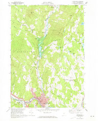
1968 Map of Montpelier
USGS Topo · Published 1973About this map
The Winooski River and North Branch converge at Montpelier, the state's capital, during a period of mid-century growth and flood control. The landscape is defined by the Wrightsville Dam, a critical piece of infrastructure managing the North Branch waters north of the city center. This 1960s-era survey reveals the dense institutional core of the city, featuring the State Capitol, Vermont College, and St Michaels Sch, all situated near the corridor of the Central Vermont railroad.
Find a feature on this map
69 named features on this map. Tap any name to fly to it.
Don’t see what you’re looking for? This feature index may not catch every label — zoom into the map to look around manually.
Map Details
Editions of this 1968 Montpelier Map
2 editions found
Other maps of this area

1919 · Montpelier
USGS Topo · 1:62,500

1921 · Montpelier
USGS Topo · 1:62,500

1922 · Barre
USGS Topo · 1:48,000

1924 · Barre
USGS Topo · 1:62,500

1939 · Plainfield
USGS Topo · 1:48,000

1940 · Plainfield
USGS Topo · 1:62,500

1943 · Plainfield
USGS Topo · 1:62,500

1944 · Montpelier
USGS Topo · 1:62,500

1947 · Corinth
USGS Topo · 1:62,500

1948 · East Barre
USGS Topo · 1:62,500