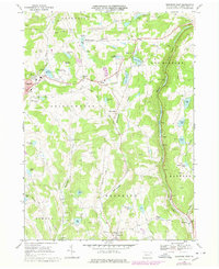
1968 Map of Montrose East
USGS Topo · Published 1978About this map
Dairy-land ridges and glacial kettle ponds characterize the landscape of Susquehanna County in this late 1960s study. The county seat of Montrose serves as the primary hub, where the Montrose Area High Sch and a Radio Tower (WPEL) sit above the waters of Lake Montrose. The map documents a significant industrial footprint through dozens of scattered Quarry sites and larger Quarries, illustrating the local stone industry that once fed the region's infrastructure. Small rural intersections like Watrous Corners and Williams Corner anchor the upland farms, while family history is preserved at the Newton Hill Cem and Rosengrants Cem. Transportation patterns are shifting during this period; while the Conrail line continues to follow the valley of Martins Creek, several miles of an Old Railroad Grade signify the retirement of older rail corridors that once linked Tiffany and Alford.
Find a feature on this map
57 named features on this map. Tap any name to fly to it.
Don’t see what you’re looking for? This feature index may not catch every label — zoom into the map to look around manually.
Map Details
Editions of this 1968 Montrose East Map
2 editions found
Other maps of this area

1892 · Dundaff
USGS Topo · 1:62,500

1932 · Susquehanna
USGS Topo · 1:62,500

1935 · Susquehanna
USGS Topo · 1:62,500

1943 · Montrose
USGS Topo · 1:62,500

1945 · Montrose
USGS Topo · 1:62,500

1946 · Tunkhannock
USGS Topo · 1:62,500

1946 · Springville
USGS Topo · 1:24,000

1946 · Hop Bottom
USGS Topo · 1:24,000
1946 · Lenoxville
USGS Topo · 1:24,000

1947 · Hopbottom
USGS Topo · 1:24,000