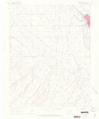
1962 Map of Montrose West
USGS Topo · Published 1966About this map
The city of Montrose sits along the Uncompahgre River in the early 1960s, serving as a hub where the Denver and Rio Grande Western RR meets an extensive network of irrigation infrastructure. The Montrose and Delta Canal winds westward from the river, cutting across the landscape to support agriculture in the Shavano Valley. This survey captures the transition from the organized town grid to the surrounding agricultural and ranching lands, marked by essential community landmarks like the Maple Grove School and Grandview Cemetery. South of the city, the terrain rises sharply toward Beaver Hill and Sims Mesa, where deep canyons like Linscott Canyon and Lindsay Canyon define the drainage patterns of the high desert environment. The presence of the Landing Strip and Radio Towers (KUBC) reflects the infrastructure of the mid-century era.
Find a feature on this map
30 named features on this map. Tap any name to fly to it.
Don’t see what you’re looking for? This feature index may not catch every label — zoom into the map to look around manually.
Map Details
Editions of this 1962 Montrose West Map
4 editions found
Other maps of this area

1909 · Montrose
USGS Topo · 1:125,000

1911 · Montrose
USGS Topo · 1:125,000

1955 · Olathe
USGS Topo · 1:24,000

1955 · Red Rock Canyon
USGS Topo · 1:24,000

1956 · Montrose
USGS Topo · 1:250,000

1956 · Moab
USGS Topo · 1:250,000

1959 · Moab
USGS Topo · 1:250,000

1959 · Montrose
USGS Topo · 1:250,000

1960 · Montrose
USGS Topo · 1:250,000

1960 · Moab
USGS Topo · 1:250,000